Could Kyushu and Shikoku Be Connected? Oita’s ¥930 Billion Undersea Tunnel Plan
Kyushu’s Oita and Shikoku’s Ehime look close on the map, but driving between them takes over six hours with no bridge or tunnel. Oita has revived a ¥930 billion subsea-tunnel plan, but for now road-trippers can enjoy the 70-minute Koku 94 Ferry instead.
Why Are Two So-Close Shores Still So Hard to Reach?
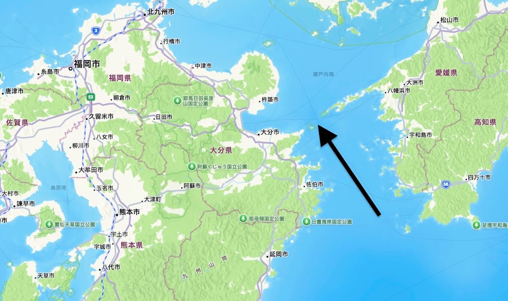
Open a map of Japan and you will notice something intriguing: the Saganoseki Peninsula in Oita Prefecture, Kyushu, and the Sadamisaki Peninsula in Ehime Prefecture, Shikoku, face each other across the sea. At the narrowest point, they are only about 14 km apart.
Yet there is still no bridge or tunnel connecting the two. Anyone driving from Oita in Kyushu to Ehime in Shikoku must first head north through the Kanmon Tunnel into Honshu, continue east along the Sanyo Expressway, then cross into Shikoku via the Seto Ohashi Bridge or the Akashi Kaikyo Bridge. The full journey is close to 600 km and takes more than six hours, not including rest stops. Japanese people often describe this situation as “near yet far”: close enough to see the opposite shore, but only reachable by taking a huge detour.
On March 23, 2026, Oita Prefecture released its latest cost estimate for the proposed Hoyo Strait undersea tunnel, quickly making it a hot topic in Kyushu transport news. The project is still far from becoming reality, but for road-trippers, there is already a practical shortcut across the sea: drive your car onto a ferry. It is a rare and memorable experience in itself, and it even makes itineraries such as “enter via Fukuoka, return via Takamatsu or Kansai” entirely feasible.
¥930 Billion Estimate Reveals the Scale of the Plan
According to figures announced by Oita Prefecture on March 23, 2026, an undersea tunnel option would include a 21.3 km subsea section, using construction methods similar to those adopted for the Seikan Tunnel, which was built under comparable environmental conditions.
In addition to the main tunnel for vehicle traffic, the project would require two more tunnels: a service tunnel for drainage, ventilation, maintenance and emergency evacuation, and an advance pilot tunnel for geological surveys. In total, three tunnels would be built, with construction costs for the strait section estimated at ¥930 billion.
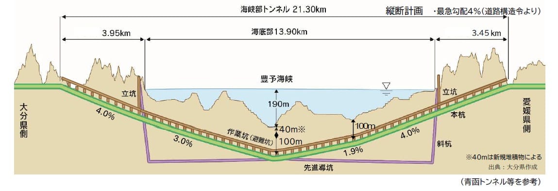
Including the connecting expressways on both sides, the Oita side would extend 17.8 km from the Oita-Miyagawauchi IC on the Higashi-Kyushu Expressway, costing about ¥100 billion. On the Ehime side, the route would extend 40.9 km from the Honai IC on the Ozu–Yawatahama Road, costing about ¥490 billion. The total cost for the full route would reach ¥1.52 trillion, nearly double Oita City’s 2022 estimate of ¥458 billion.
Oita Governor Kiichiro Sato explained that the difference is mainly due to the newly included costs of the service tunnel and advance pilot tunnel, as well as rising prices.
The Hoyo Strait route was first written into Japan’s Fifth Comprehensive National Development Plan in 1998 as part of the “Pacific New National Axis” concept. It is one of Japan’s six major strait-crossing projects. Around 2008, however, it was criticized as an “unnecessary public works project” and effectively placed in long-term suspension. Governor Sato, who took office in 2023, has since revived efforts to promote it.
Oita Prefecture argues that if the tunnel is completed, semiconductor products from TSMC’s Kumamoto plant and agricultural products from Kyushu could be transported to Kansai more easily. The tunnel could also serve as an alternative route if the Sanyo Expressway is closed due to earthquakes or typhoons.
That said, even the governor has acknowledged that the project would require national-level support to move forward. In the short term, substantial progress is unlikely. For now, crossing the sea still means taking a ferry or making the long detour by road.
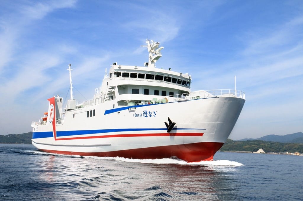
Koku 94 Ferry: Connecting the Two Islands in 70 Minutes
There are currently three ferry routes between Kyushu and Shikoku, but the most convenient for self-drive travelers is the Koku 94 Ferry (国道九四フェリー). It runs from Saganoseki Port in Oita to Misaki Port in Ehime, taking only about 70 minutes. At roughly 31 km, it is the shortest sea route between Kyushu and Shikoku.
The route is called “94” because it forms the sea section of Japan’s National Route 197. In other words, part of the national highway continues across the water, with the same official status as an on-land national road.
For road-trippers, the biggest advantages are frequent sailings and simple boarding procedures. There are around 16 departures per day, from the first ferry at 7 a.m. to the last at 11 p.m., generally about once an hour. Even if you miss one sailing, the wait is usually no more than an hour.
At present, a one-way fare for a private car under 5 meters, including the driver, is about ¥9,800. Additional adult passengers cost around ¥1,200 each. Actual fares should be checked on the official website before departure. Online reservations through the official website receive a 3% discount and can be made from 59 days before the sailing date. During peak seasons such as New Year, Golden Week and Obon, ferries are often fully booked, so reservations two to three months in advance are recommended.
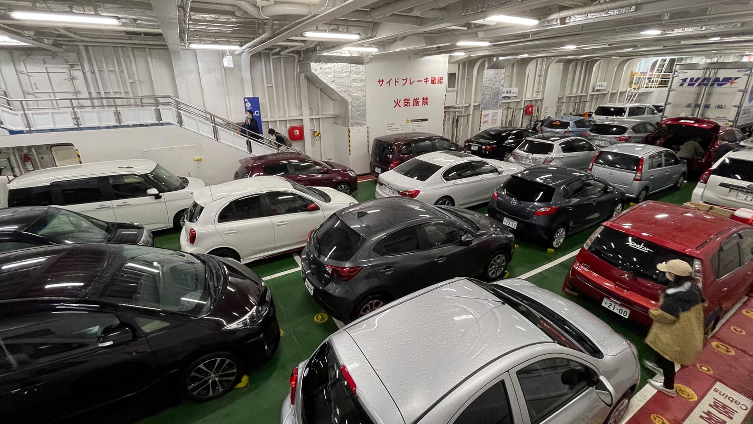
The actual process is straightforward. Arrive at Saganoseki Port around 30 minutes before departure, follow the signs into the reserved or same-day vehicle lane, then get out and exchange your ticket at the counter. Online reservation holders need to show their booking confirmation and vehicle registration document. After that, simply follow staff instructions to board.
On board, there are tatami-style resting areas, seating areas, a small shop and observation seats. During the 70-minute crossing, you can leave your car and stretch your legs. With a bit of luck, dolphins may occasionally appear in the Bungo Channel. Along the way, you may also spot container ships, tankers and Japan Maritime Self-Defense Force vessels.
From the Ferry Straight Onto a Scenic Road: Sadamisaki Melody Line
Once you arrive at Misaki Port in Ehime, you immediately connect to one of the region’s signature scenic drives: the Sadamisaki Melody Line (佐田岬メロディーライン). This is the roughly 39 km section of National Route 197 running from Misaki Port to Honai in Yawatahama City.
The Sadamisaki Peninsula is about 40 km long, making it Japan’s longest peninsula. Its western tip is also the westernmost point of Shikoku.
The road follows the ridge of the peninsula and is built as a high-standard two-lane route. On one side lies the Seto Inland Sea; on the other, the Uwa Sea. The rare sensation of seeing ocean views on both sides at once makes this one of Japan’s most distinctive coastal drives.
Along the route are several viewpoints and roadside stations, including Seto Kaze no Oka Park, where you can see 58 giant wind turbines, and the Seto Observation Rest Area, which offers views across to the Saganoseki Peninsula in Kyushu.
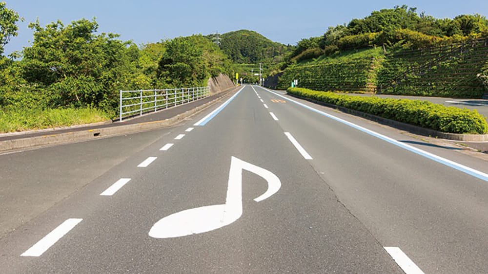
The name “Melody Line” is not just for show. Certain sections of the road surface are carved with special grooves. When cars drive over them at 50 km/h, the friction between the tires and road produces melodies. There are three musical sections: “Mikan no Hana Saku Oka” near Roadside Station Seto Agricultural Park, “Umi” in the Mitsukue area of Ikata Town, and “Seto no Hanayome” in Honai, Yawatahama City.
The road is both fun and practical, as the melodies encourage drivers to maintain a safe speed. It was the first melody road in Shikoku and has been featured by several Japanese media outlets as one of the country’s great scenic drives.
Worth a Stop Before Boarding: Saganoseki’s Premium Brand Fish
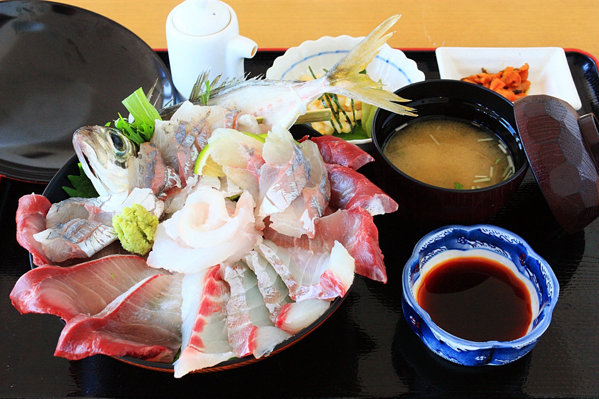
Before taking the Koku 94 Ferry, Saganoseki Port on the Oita side is well worth a stop for food. Saganoseki is famous across Japan for two premium fish brands: Seki Aji and Seki Saba.
These are horse mackerel and mackerel caught in the Bungo Channel off Saganoseki, an area also known as Hayasui Seto. Fishermen catch them one by one using traditional single-line fishing methods. Thanks to the fast currents and deep waters, the fish have especially firm, springy flesh. Served as live sashimi, they are often rated even higher than standard sea bream or flounder.
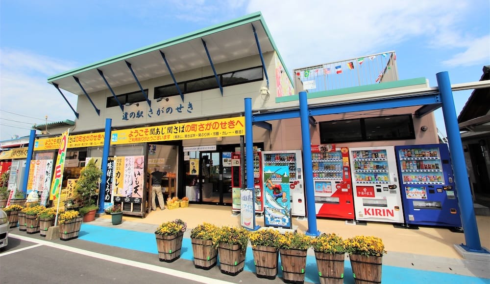
here are two convenient food stops around Saganoseki. The first is Roadside Station Saganoseki, located on elevated coastal ground along National Route 197. Its observation deck offers sweeping sea views stretching from the Kunisaki Peninsula toward Shikoku. Signature dishes include Seki Aji rice bowls, Seki Saba rice bowls, miso soup with local kurome seaweed, octopus balls and goat-milk soft serve.
The second is Amabe no Sato Seki Aji Seki Saba-kan. The first-floor shop sells souvenirs such as dried Seki Saba, while the second-floor restaurant serves seafood rice bowls with views from the Sekizaki Peninsula toward the Tsurumi Peninsula. Around March each year, the Saganoseki branch of the Oita Prefectural Fisheries Cooperative holds the Seki Aji and Seki Saba Festival, one of the area’s major local events.
Practical Information
Koku 94 Ferry
- Route: Saganoseki Port to Misaki Port
- Crossing time: About 70 minutes
- Daily sailings: Around 16 departures, from 7 a.m. to 11 p.m., roughly hourly
- Adult passenger fare: About ¥1,200
- Vehicle fare: About ¥9,800 for cars under 5 meters, including the driver
- Fuel surcharge: Around ¥100 extra
- Reservation discount: 3% discount for bookings via the official website; reservations open 59 days before departure
- Official website: koku94.jp
- Note: Fares and timetables may vary by season. Check before departure. Advance reservations are strongly recommended during peak periods.
Suggested Self-Drive Routes
- From Oita City: Take the Higashi-Kyushu Expressway to Oita-Miyagawauchi IC, then follow National Route 197 to Saganoseki Port. Driving time is about 60 minutes.
- From Beppu Onsen: Drive south via the Beppu–Oita coastal road and National Route 197. Driving time is about 90 minutes.
- From Yufuin: Driving time is about 90 to 120 minutes via Oita City.
- After disembarking at Misaki Port: Follow National Route 197 east along the Sadamisaki Melody Line for about 39 km to Yawatahama City. From there, connect to the Matsuyama Expressway for central Matsuyama. Total driving time is about two hours.
Roadside Station Saganoseki
- Address: 989-6 Ohira, Oita City, Oita Prefecture
- Tel: 097-576-0770
- Opening hours: 9 a.m. to 6 p.m., open year-round
- Restaurant hours: Summer 10:30 a.m. to 4 p.m.; winter 10 a.m. to 3:30 p.m. Last orders are 30 minutes before closing.
- Recommended items: Seki Aji rice bowl, Seki Saba rice bowl, kurome seaweed octopus balls, goat-milk soft serve
- Access: About 15 minutes by car from Miyagawauchi IC on the Oita Expressway; about 10 minutes by car from JR Kozaki Station
Amabe no Sato Seki Aji Seki Saba-kan
- Address: 949 Shiraki, Oita City, Oita Prefecture
- Tel: 097-575-2338
- First-floor shop: 10 a.m. to 5 p.m.
- Second-floor restaurant: 10 a.m. to 9 p.m., last order 8:30 p.m.; closes when sold out
Spots Along the Sadamisaki Melody Line
- Roadside Station Seto Agricultural Park: Home to the “Mikan no Hana Saku Oka” melody-road section and known for Uwa Sea whitebait rice bowls.
- Seto Kaze no Oka Park: A viewpoint with 58 wind turbines and panoramic views of both the Seto Inland Sea and the Uwa Sea.
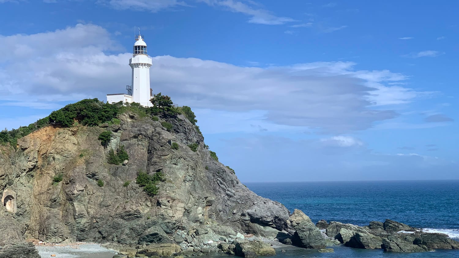
- Sadamisaki Lighthouse: The westernmost point of Shikoku. Built in 1918, the lighthouse is about a 20-minute walk from the parking area.
Tips Before You Go
The Koku 94 Ferry often fills up during peak seasons. Without a reservation, you may have to wait one or two sailings if the ferry is full.
If you plan to enjoy the Sadamisaki Melody Line slowly, set aside at least half a day. There are many viewpoints along the route, and you will likely want to stop often for photos. To hear the melody-road sections clearly, drive at around 50 km/h. Too fast or too slow, and the tune will become distorted.
The ¥930 billion estimate for the Hoyo Strait undersea tunnel is certainly eye-catching. But for travelers planning a Kyushu–Shikoku road trip today, the truly practical option remains the 70-minute shortcut by ferry.
Start with Saganoseki’s famous Seki Aji and Seki Saba, enjoy the views across the Hoyo Strait from the deck, then drive onto the Sadamisaki Melody Line for twin sea views and a road that literally sings. This journey is already a classic Kyushu–Shikoku self-drive route. While the ferry still runs frequently, take the chance to experience this “near yet far” sea highway for yourself. It may well have more character than the tunnel ever will.