Kumamoto Shook Again. Is Fukuoka Next?
A clear, traveler-friendly guide to the July 2026 Kumamoto earthquake, Kyushu’s major fault systems, what the risk means for Fukuoka, and which routes and attractions are currently affected.
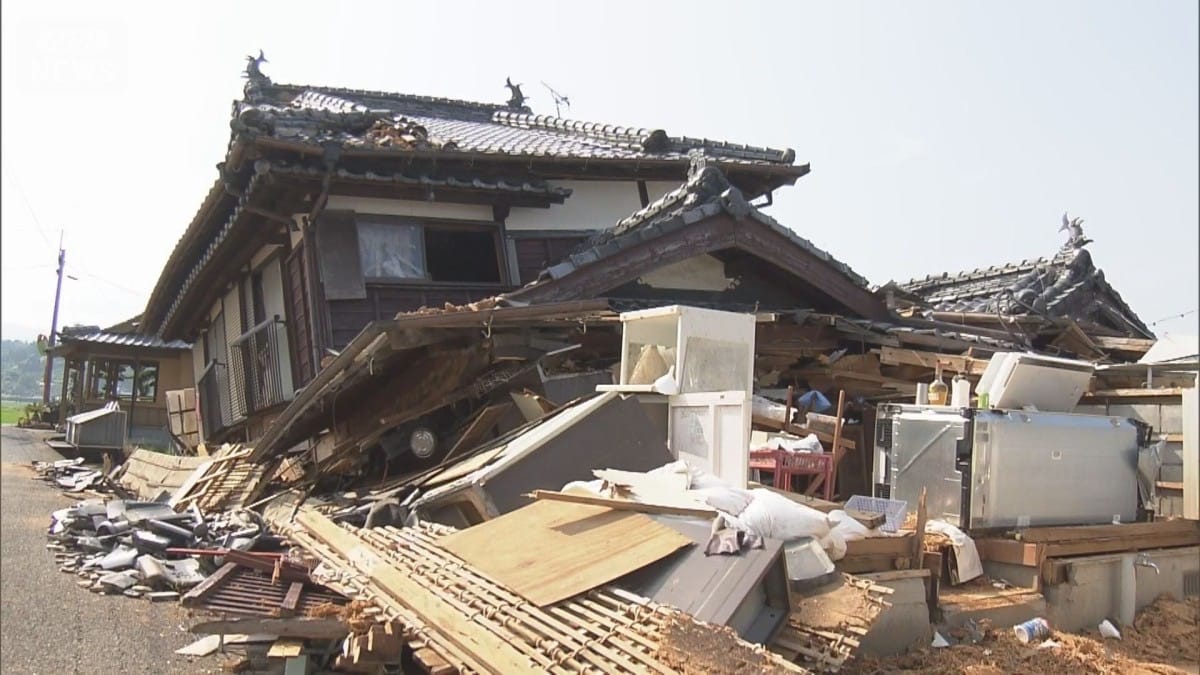
Our thoughts are with those who lost their lives and everyone affected by this earthquake. The article below focuses on the geological background and practical travel information rather than commenting on the disaster itself.
When headlines contain phrases such as “Kyushu earthquake” and “seismic intensity 7,” it is easy to imagine the entire island shaking violently. The reality is far more localized, and it can be checked place by place. Kumamoto has recorded a maximum seismic intensity of 7 twice within a decade, which shows that earthquakes in Kyushu do not occur at random. They tend to repeat along specific fault lines. Both the location and the underlying mechanism are known factors, making it possible to assess the risk more clearly.
How different was the reality from the headlines?
The main difference is geographical scale. The strongest shaking was concentrated in a narrow belt along the fault zone in central and southern Kumamoto Prefecture, an area much smaller than the word “Kyushu” might suggest.
For the earthquake on July 28, 2026, the observed seismic intensities were as follows:
| Location | Observed intensity | What it means for travelers |
|---|---|---|
| Uki City and Hikawa Town | JMA intensity 7 | Epicentral area and the most severely affected zone |
| Yatsushiro City, Mashiki Town, and Minami Ward of Kumamoto City | JMA intensity 6 upper | Most building damage was concentrated here |
| Chuo, Higashi, Nishi, and Kita wards of Kumamoto City | JMA intensity 5 upper | Kumamoto’s trams have resumed service, and no deaths were reported in the city |
| Yanagawa and Okawa, Fukuoka Prefecture | JMA intensity 5 lower | The highest intensity recorded in Fukuoka Prefecture |
| Fukuoka City | JMA intensity 3 | Noticeable shaking but no major damage; visitor attractions are operating normally |
The same perspective applies elsewhere. The Aso area lies about 50 kilometers from the epicenter, and no major damage was confirmed there; accommodation facilities in Oita Prefecture also remained open. The local tourism industry is instead facing a different problem: large numbers of cancellations in places that were not directly affected. One long-established hotel in Kagoshima City, for example, lost bookings for around 600 guests. Hotels and ryokan across the region are making the same request: contact your accommodation first, check the actual local conditions, and then decide whether to change your plans.
Which fault caused the July 2026 Kumamoto earthquake?
The answer is the Hinagu Fault Zone (日奈久断層帯/ひなぐだんそうたい). According to an assessment released by Japan’s Earthquake Research Committee on July 29, 2026, the source fault of the M7.1 earthquake lay beneath the northeastern part of the Hinagu section and part of the Takano–Shirahata section of the Hinagu Fault Zone. The rupture extended for roughly 30 kilometers.
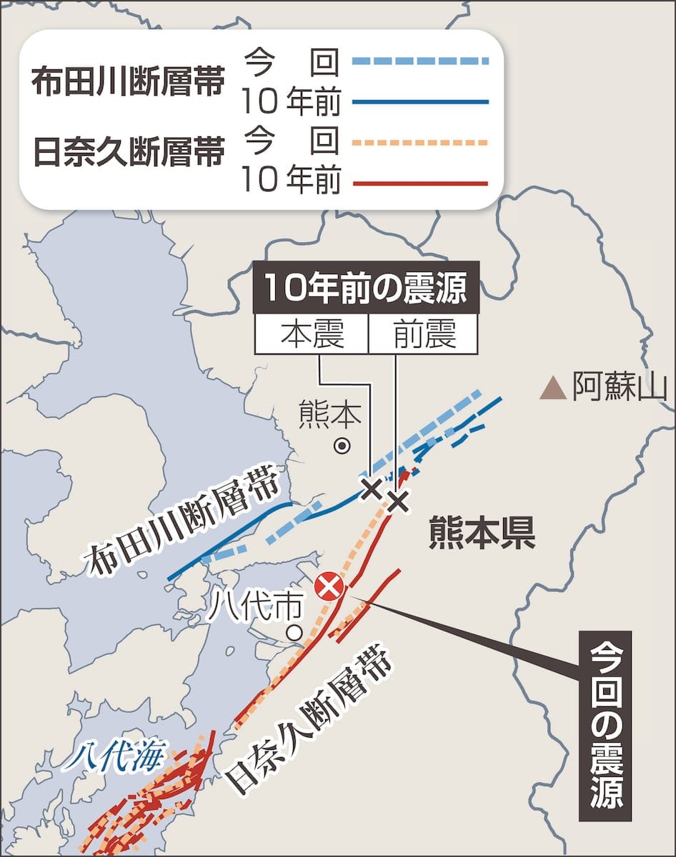
An active fault is essentially a long-lived fracture in the Earth’s crust. Stress builds as the rock on either side is compressed; once it reaches its limit, the fault slips suddenly, releasing energy as an earthquake. The Hinagu Fault Zone and the connected Futagawa Fault Zone (布田川断層帯) cross central and southern Kumamoto Prefecture and together form one of the most closely watched active-fault systems on land in Kyushu.
| Item | Details |
|---|---|
| Time | July 28, 2026, at 4:27 p.m. |
| Magnitude | JMA magnitude 7.1; focal depth 16 kilometers |
| Maximum intensity | JMA intensity 7 (Uki City and Hikawa Town) |
| Mechanism | A shallow crustal earthquake caused by strike-slip faulting |
| Tsunami | Tsunami advisories were issued for the Ariake Sea and Yatsushiro Sea, then lifted in full at 6:10 p.m. the same day |
| Associated fault | Hinagu Fault Zone (the northeastern Hinagu section and part of the Takano–Shirahata section) |
Why did Kumamoto experience two major earthquakes within a decade?
Because the 2016 earthquakes did not rupture the entire fault system. In April 2016, an M6.5 earthquake struck the Takano–Shirahata section, followed two days later by an M7.3 earthquake on the Futagawa section. The two fault zones ruptured in sequence. Farther south, however, the Hinagu and Yatsushiro Sea sections did not move. In Japanese, these are described as ware-nokori, meaning segments left unruptured.
An analysis released by the National Institute of Advanced Industrial Science and Technology on July 30, 2026, filled in the rest of the picture. The 2016 fault movement changed the stress conditions in the surrounding crust, and the epicenter of the 2026 earthquake lay squarely within an area where that stress had increased. In other words, the earthquake a decade earlier did not eliminate the risk on the southern section; it made that section more likely to slip. This kind of one-segment-after-another sequence is not unusual in active-fault research, and it is one reason scientists can identify where future risk is concentrated.
The southernmost Yatsushiro Sea section of the Hinagu Fault Zone remains unruptured. Long-term assessments indicate that it could produce an earthquake of around M7.3. Because the section lies beneath the sea, authorities continued to remind coastal communities to remain alert for tsunamis after the earthquake. Travelers planning routes along the southern Kumamoto coast should keep that in mind.
| Section | Location | Estimated earthquake size | 2016 | 2026 |
|---|---|---|---|---|
| Futagawa section | From the western rim of the Aso caldera to the Uto Peninsula | Around M7.0 | Ruptured | Did not rupture |
| Takano–Shirahata section | The area from Mashiki to Kosa | Around M6.8 | Ruptured | Partially ruptured |
| Hinagu section | The area from Kosa to Yatsushiro | Around M7.5 | Did not rupture | Northeastern part ruptured |
| Yatsushiro Sea section | Beneath the Yatsushiro Sea | Around M7.3 | Did not rupture | Did not rupture |
Sources: long-term assessments by Japan’s Headquarters for Earthquake Research Promotion, the Earthquake Research Committee’s assessment of July 29, 2026, and the National Institute of Advanced Industrial Science and Technology.
Does Fukuoka have an active fault too?
Yes. One runs directly beneath the city center, although the situation is quite different from Kumamoto’s. The Kego Fault Zone (警固断層帯/けごだんそうたい) extends from the Genkai Sea through Hakata Bay, crosses Fukuoka City’s Chuo and Minami wards, and continues through Kasuga, Onojo, Dazaifu, and Chikushino. It is about 55 kilometers long. The fault is named after the Kego neighborhood in central Fukuoka; Kego Park and Kego Shrine, beside the Tenjin shopping district, share the same place name. In other words, many visitors walk above the fault without ever realizing it.
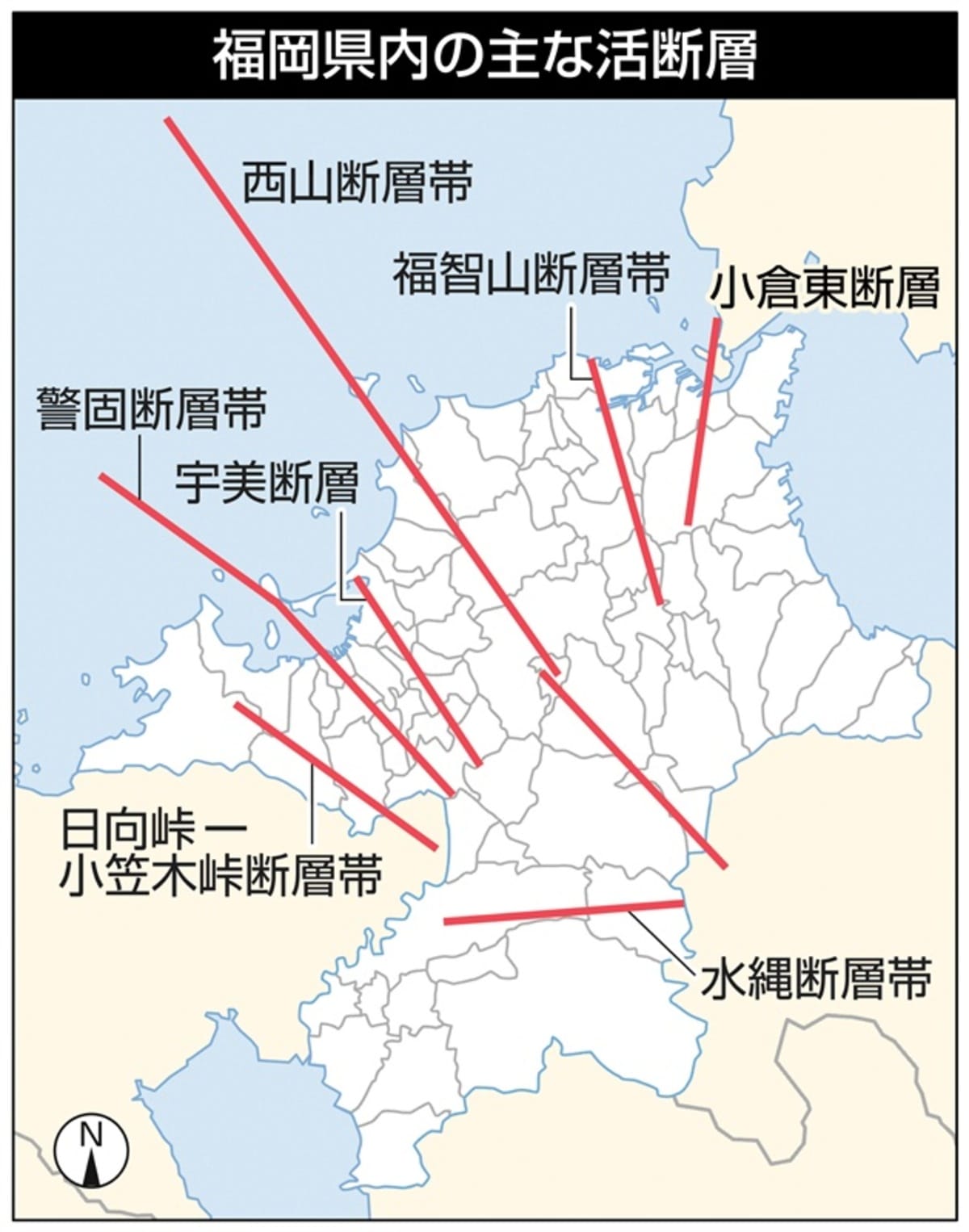
The Kego Fault Zone is divided into two sections with almost opposite histories:
- Northwestern section: This section produced the West Off Fukuoka Prefecture Earthquake (福岡県西方沖地震) on March 20, 2005. The M7.0 earthquake reached a maximum JMA intensity of 6 lower, killing one person and injuring around 1,200. Roughly half the homes on Genkaijima Island were completely destroyed. It was the largest earthquake recorded in the Fukuoka City area. Because this section released energy relatively recently, the short-term probability of another earthquake of comparable size is assessed as low.
- Southeastern section: This roughly 27-kilometer section runs from the waters south of Shikanoshima Island to Chikushino and has not ruptured in modern times. Long-term assessments suggest it could produce an earthquake of around M7.2. Its most recent movement occurred approximately 4,300 to 3,400 years ago, with an average recurrence interval of about 3,100 to 5,500 years. The estimated probability of an earthquake within the next 30 years is 0.3% to 6%. Using the upper end of that range, it ranks among the more elevated probabilities for Japan’s major active faults.
It is important to understand that “elevated” here is a geological term measured on a timescale of thousands of years. An average recurrence interval of roughly 3,000 to 5,500 years means this fault moves very slowly.
Headlines often seize on estimates such as “1,800 deaths expected in a Fukuoka earthquake.” Fukuoka City publishes these scenarios on its disaster-prevention maps so residents and planners can make long-term decisions about buildings, infrastructure, and preparedness. They are not a warning that an earthquake is believed to be imminent.
Similar fault systems are found across Kyushu. The Beppu–Haneyama Fault Zone (別府-万年山断層帯) runs through the Yufuin and Beppu areas. The western part of the Oita Plain–Yufuin section has an estimated 2% to 4% chance of rupturing within 30 years. The eastern part of the Beppu Bay–Hiji section last moved during the 1596 Keicho Bungo earthquake. The same active underground structures that create seismic risk also help explain why hot springs rise so abundantly in these areas.
Do you need to change your Kyushu itinerary?
Most itineraries do not need to change. The main adjustments are for overland routes south of Kumamoto. Transport within Kumamoto City has largely recovered, tram services are running normally, and water service has been almost fully restored. The significant remaining disruptions are on the Shinkansen and sections of the expressway between Kumamoto and Kagoshima. For now, flights or a detour via eastern Kyushu are the most practical alternatives.
Here are the main transport conditions as of early August 2026:
| Route or section | Status |
|---|---|
| Kyushu Shinkansen: Hakata–Kumamoto | Normal timetable restored, including through-services to and from the Sanyo Shinkansen |
| Kyushu Shinkansen: Kumamoto–Shin-Minamata | Suspended; JR Kyushu says restoration during August will be difficult |
| Kyushu Shinkansen: Shin-Minamata–Kagoshima-Chuo | Restoration plans under review |
| Nishi Kyushu Shinkansen: Takeo-Onsen–Nagasaki | Operating normally |
| JR Kagoshima Main Line: Kumamoto–Uto | Operating on a reduced timetable |
| JR Kagoshima Main Line: Uto–Yatsushiro | Suspended; restoration during August will be difficult |
| JR Kagoshima Main Line: Sendai–Kumanojo | Normal service scheduled to resume on August 5 |
| Limited Express Yufuin no Mori (ゆふいんの森) | Services 1, 2, 5, and 6 are operating normally; services 3 and 4 are running as Limited Express Yufu trains because of a separate rolling-stock fault unrelated to the earthquake, through September 30 |
| B&S Miyazaki highway bus | All services suspended through August 31 |
| Kyushu Expressway: Matsubase IC–Ebino IC | Expected to reopen by the end of August |
| Kumamoto City Tram | Operating normally |
| Kumamoto Castle | Temporarily closed after stone walls collapsed in around 40 locations |
Conditions are changing frequently, so check the official websites of JR Kyushu, NEXCO West, and individual attractions before departure.
As for long-term risk, Japan’s 2020 National Seismic Hazard Map estimated a 6.2% chance that Fukuoka City would experience shaking of JMA intensity 6 lower or greater within 30 years. That figure is designed for residents making three-decade planning decisions. For a trip lasting only a few days, the chance of encountering such an event is extremely small. The 2024 Noto Peninsula earthquake was a reminder that major earthquakes can occur even in places considered relatively low-risk, but the lesson is to prepare rather than automatically cancel a trip.
Three simple earthquake-safety steps for travelers
Install an alert app before you leave, check the evacuation map when you arrive, and protect your head if the shaking starts. Those three actions cover most of what a traveler needs to know, and together they take less than ten minutes.
1. Install the Safety tips app before your trip
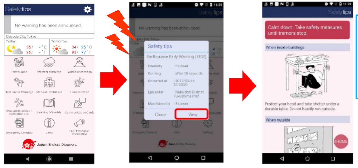
This free disaster-information app is supervised by the Japan Tourism Agency and supports 15 languages. Once you set your location, it sends an Earthquake Early Warning when shaking of JMA intensity 4 or greater is forecast there. It also provides tsunami alerts, evacuation-shelter information, and communication cards. Japan’s earthquake early warnings generally provide only a few seconds to a few dozen seconds of notice, so protecting your head immediately is the most effective response.
2. Check two things when you arrive at your hotel
Look at the evacuation-route diagram on the back of your room door, then find the designated evacuation site nearest the hotel. Keep your shoes beside the bed and make sure your luggage does not block the door. These small habits can make a real difference if an earthquake strikes at night.
3. Know what to do when the shaking starts
Indoors: Protect your head with a bag or pillow, move away from windows and hanging objects, and take cover beneath a sturdy table. Do not immediately run outside, and do not use elevators after the shaking stops.
Outdoors: Watch for falling signs, glass façades, and brick walls. The only fatality in the 2005 West Off Fukuoka Prefecture Earthquake was caused by a collapsing brick wall.
Near the coast: After strong shaking, move away from the shoreline and river mouths as quickly as possible. Do not wait for an official warning.
Buildings in Japan are generally constructed to strict earthquake-resistance standards. Hotels, stations, and shopping centers have clear evacuation signs, and staff are trained to respond. In most cases, travelers simply need to follow instructions rather than make their own judgment calls.
Practical places to learn about earthquakes
Fukuoka Citizens’ Disaster Prevention Center (福岡市民防災センター)
- Address: 1-3-3 Momochihama, Sawara Ward, Fukuoka City
- Opening hours: 9:30 a.m. to 5:00 p.m. (last admission at 4:30 p.m.)
- Closed: Mondays; the final Tuesday of each month, or the following day if it falls on a public holiday; and December 28 to January 4. Open daily during the summer holiday period from July 21 to August 31
- Admission: Free
- Experiences and exhibits: JMA intensity 7 earthquake simulator, VR disaster-preparedness experience, strong-wind simulator, smoke-evacuation experience, a special exhibition on the 2005 West Off Fukuoka Prefecture Earthquake, and a retired helicopter
- Experience program: Approximately 80 minutes. Groups of 10 or more must book in advance; individual visitors are advised to call ahead (experience hotline: 092-847-5991)
- Getting there: About a 15-minute walk from Nishijin Subway Station, or a three-minute walk from the Seinan Chuko-mae Nishitetsu bus stop
- Official website
- Tip: It is close to Fukuoka Tower and the Fukuoka City Museum, making it easy to include in a Momochihama itinerary
Kumamoto Earthquake Memorial Museum KIOKU (熊本地震震災ミュージアム KIOKU)
- Address: 5343-1 Kawayō, Minamiaso Village, Aso District, Kumamoto Prefecture, on the former Tokai University Aso campus
- Phone: 0967-65-8065
- Current status: Temporarily closed from July 29, 2026, because of the 2026 Kumamoto earthquake. No reopening date has been announced
- Exhibits: The former Building No. 1, which was crossed directly by the fault, and the visible surface rupture have been preserved. Indoor exhibits include disaster artifacts, a film explaining earthquake mechanisms, and a large three-dimensional model
- Official website
- Tip: It will be well worth a dedicated visit once it reopens, but check the latest announcement on the official website before setting out
Other useful official sources include the Japan Meteorological Agency’s page on the 2026 Kumamoto earthquake, the Headquarters for Earthquake Research Promotion, Fukuoka Prefecture’s disaster-prevention website, and the Mamoru-kun disaster-preparedness app.
Frequently asked questions
Q: Is it safe to visit Fukuoka now? A: Yes. Tourism, transport, and commercial activity in Fukuoka have continued as normal. The strongest shaking in Fukuoka Prefecture during this earthquake was JMA intensity 5 lower in the southern cities of Yanagawa and Okawa. Fukuoka City experienced only mild shaking and no major damage. In the longer term, the southeastern section of the Kego Fault Zone remains a known risk, but basic earthquake preparedness is sufficient for visitors.
Q: Did the Kumamoto earthquake make the Kego Fault in Fukuoka more dangerous? A: As of early August 2026, no official assessment has found a direct connection, and the long-term probability estimates for the Kego Fault Zone have not been revised because of this earthquake. The two belong to different fault systems and are separated by southern Fukuoka Prefecture and northern Kumamoto Prefecture. Watch for any follow-up announcements from the Headquarters for Earthquake Research Promotion.
Q: Are Yufuin and Beppu affected? A: The impact on Oita Prefecture was limited. Accommodation facilities are operating normally, and the main Yufuin no Mori limited-express services continue to run. The Beppu–Haneyama Fault Zone is part of the region’s long-term geological background, measured over thousands of years; it is not an immediate development caused by this earthquake.
Q: What should I do when I receive an Earthquake Early Warning? A: Protect your head immediately, crouch down, and move away from glass and high shelves. Do not spend precious seconds reading the full message. The warning may arrive only a few seconds to a few dozen seconds before the shaking, so act first. Hotels and stations in Japan will also make announcements and staff will give instructions. Follow them.
Q: Can I visit Kumamoto now? A: Transport within Kumamoto City has largely recovered, and Shinkansen services between Hakata and Kumamoto are back to their normal timetable. Kumamoto Castle is temporarily closed, however, and the Shinkansen and expressway south of Kumamoto remain disrupted. Much of the local accommodation capacity is currently being used for recovery work, so confirm that both your lodging and itinerary are feasible before traveling. Those hoping to support the area may ultimately help more by visiting once daily life and services have stabilized.
Earthquakes cannot be predicted precisely, but Kyushu’s seismic risk is not difficult to understand. Knowing the background helps replace vague anxiety with practical preparation. Learn which faults lie beneath the region, install an alert app, and remember to protect your head. Then, even if an earthquake does occur, you will know how to respond and keep the risk as low as possible.